Archaeologists have used lidar scanning technology to discover a network of medieval cities beneath the forest surrounding Angkor Wat, an ancient temple city in the heart of Cambodia. The discovered cities are between 900 and 1,400 years old, some of which cover an area comparable to Cambodia’s modern capital, Phnom Penh. The findings were published in the Journal of Archaeological Science on 13 June.
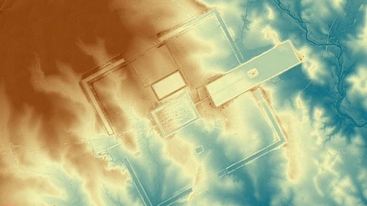
The discovered cities are the result of the most extensive airborne archaeological study ever undertaken, covering 734 square miles (1,901km2) back in 2015. Helicopter-mounted Lidar technology was used to fire laser pulses at the forest canopy in the vicinity of Angkor Wat during flight. The laser beams penetrated the vegetation, rebounded off the forest floor and returned to the scanner after a short delay. The delay was used to determine the elevation of each individual data point obtained by the scanner, allowing a 3D model of the underlying terrain to be produced.
Lidar systems can measure up to four return values for each laser pulse emitted, along with an intensity value for each. The first return will represent the highest foliage of the forest canopy being hit by the laser pulse, with subsequent returns being either be lower portions of foliage or, eventually, the ground itself. The wavelength of the laser doesn’t enable it to pass through trees or leaves, but on average there will be enough gaps in the vegetation that some of the pulses will rebound off the forest floor. Post-processing the data allows for maps of both the foliage and the terrain to be made from the same set of scans.
‘We have entire cities discovered beneath the forest that no one knew were there – at Preah Khan of Kompong Svay and, it turns out, we uncovered only a part of Mahendraparvata on Phnom Kulen in the 2012 survey,’ said Australian archaeologist Dr Damian Evans, whose findings were published in the Journal of Archaeological Science. ‘This time we got the whole deal and it’s big, the size of Phnom Penh big.’
The 2012 Lidar survey Evans conducted uncovered a complex urban landscape connecting medieval temple-cities, such as Beng Mealea and Koh Ker, to Angkor. The success of the project enabled Evans to obtain funding from the European Research Council for a similar survey to be carried out in 2015, only on a much larger scale. The 2015 survey uncovered elaborate water systems that were built hundreds of years before historians believed the technology existed.
Further Information:
Paper in Journal of Archaeological Science: 'Airborne laser scanning as a method for exploring long-term socio-ecological dynamics in Cambodia'
