A lost Maya city has been discovered in Mexico thanks to lidar technology.
Together with archaeology partners, researchers from the University of Houston discovered the city in the jungles of Campeche, on Mexico’s Yucatan Peninsula.
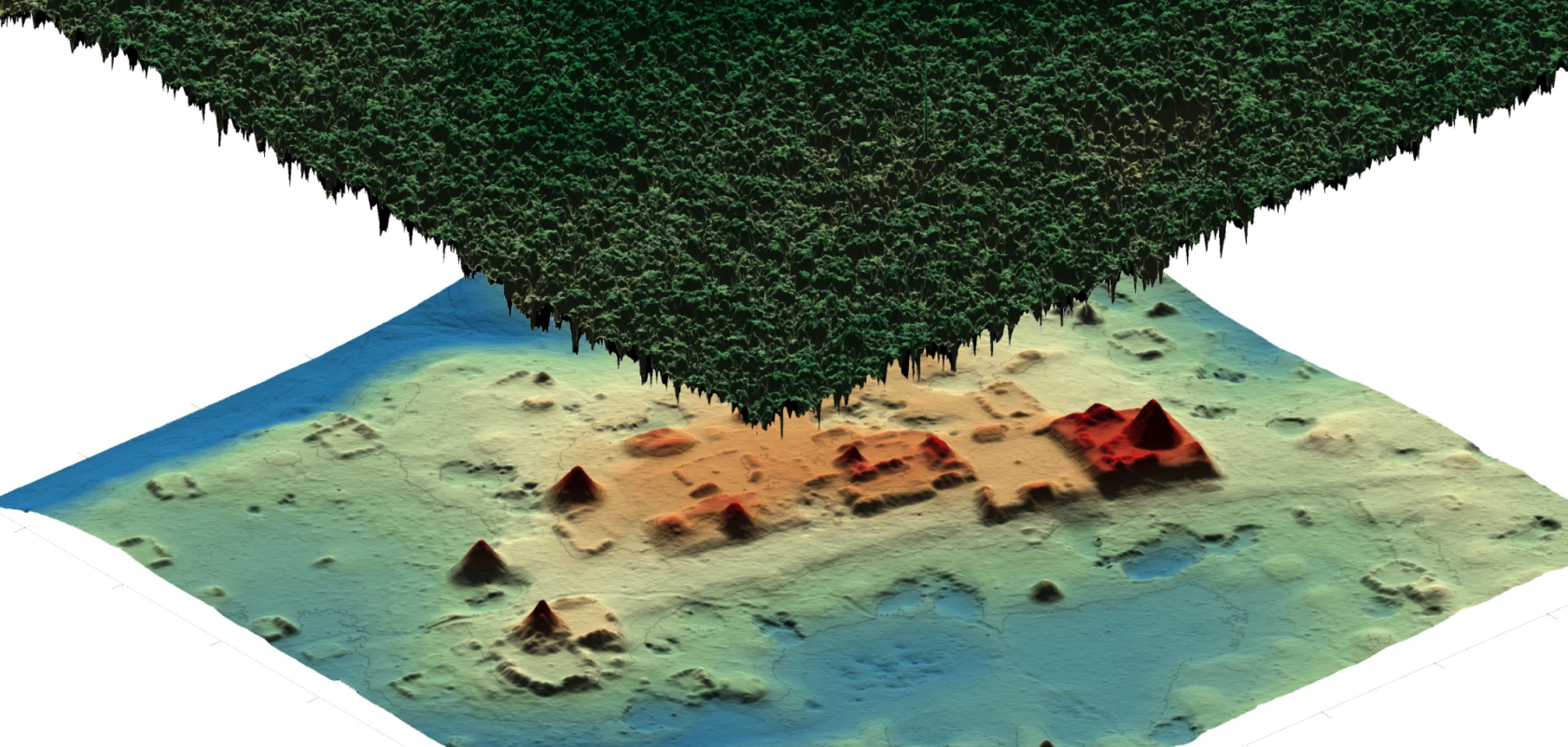
The city, now dubbed Ocomtún (‘stone column’ in Maya), was found using lidar technology. Experts from the National Center for Airborne Laser Mapping (NCALM) at the university flew a plane above sites of interest and scanned the landforms below.
Lidar allows the team to collect data in areas that are difficult to enter on foot, such as jungles and rainforests.
Among their findings were 50-foot-tall structures resembling pyramids, a ball game field, and pottery that dates the city to between the years 600 and 800. They also discovered that the terrain was elevated and surrounded by wetlands.
“You can compare us to ultrasound technicians. We are the first to see the baby, but the doctor will tell you all about it and confirm the findings,” said Juan Carlos Fernandez-Diaz, co-principal investigator of NCALM.
He added: "When we see it on the computer we think, ‘Wow!’ We are seeing these things for the first time in 1,000 years. It’s like time travel to see under the vegetation, to the roads, canals and ponds as they were that long ago.”

Researchers fly over the bay and city of Campeche. (Image: University of Houston)
The team used lidar technology to shoot rapid laser bursts at the ground billions of times, measuring the time it took for the pulses to hit the ground and return to their source. This generated a three-dimensional map with topographical markings, revealing rising structures and other hidden features.
The team’s findings were then handed over to Ivan Ṡprajc from the Slovenian Academy of Sciences and Arts and his team of archaeologists, working under Mexico's National Institute for Anthropology and History (INAH).
“The site served as an important centre at the regional level,” Ṡprajc said in a statement released by INAH. “For Mexico and Central America, we are the premier research centre that has been able to do this quickly and affordably. We have over ten years of these kinds of discoveries.”
The team’s track record includes finding ruins in 2012 in an area of Eastern Honduras, the 2016 mapping of over 80,000 Maya structures including previously unknown Maya settlements; and agricultural and defensive structures in the Guatemalan Peten jungle.