Whether it is the eerie setting of an abandoned nuclear power plant, or the chaotic scenes of an active warzone, there are areas in the world considered too dangerous to travel in without assistance. Instead, we often rely on a range of robust technologies that are able to enter these hazardous environments and obtain accurate data without putting lives at risk.
The emergence of unmanned aerial vehicles (UAVs), or drones, in recent years has created a cost-effective means of sending various analytical tools into dangerous areas.
Lidar-equipped UAV systems are now being used by researchers in Bristol to produce 3D radiation maps of radioactive sites in Japan, while researchers at the Swedish Defence Research Agency (FOI) are using similar systems alongside their national armed forces to identify enemy troops and penetrate thick vegetation in warzones.
Radioactive mapping
Peter Martin is a member of a research group at the University of Bristol that is using UAV-mounted lidar systems to produce 3D radiation maps of the 2011 Fukushima Daiichi nuclear disaster site in Japan. The group’s recent work in the International Journal of Applied Earth Observation and Geoinformation demonstrates how a single beam AR2500 laser rangefinder unit from US-based Acuity Laser was used to generate a 3D point-cloud of the hazardous site, onto which a radiation contamination map of the same area – obtained via a GR1 miniature gamma-ray spectrometer from Kromek mounted alongside the rangefinder – could be rendered.
‘UAV’s are capable of producing radiation maps where it is either not practical or desirable to send human operatives,’ explained Martin, adding that the production of three-dimensional radiation maps using UAV-mounted lidar produces a very graphical means of visualising the extent and nature of radioactive contamination in dangerous areas.
The researchers flew the AR2500 lidar system over the hazardous site and used it to return a voltage value directly proportional to the height of the UAV every half second. By using these values, in combination with radiation data collected by the Kromek spectrometer, an accurate radiation map of the site could be produced. A 3D ground profile of the area was then generated by subtracting the lidar height values recorded by the UAV from a separate set of GPS-derived height data, and then exporting the resulting values into geographical mapping software. The triangular network mesh of the site produced by the program could then be overlain with the radiation map to produce a full 3D representation of the contamination in the zone.
In choosing suitable photonics equipment to carry out aerial radiation surveys, the researchers had to consider each device’s capability in addition to how it would affect the overall practicality of the UAV platform. ‘As we are conducting radiological surveys in environments potentially contaminated by significant levels of ionising radiation (with substantial health implications), it is desirable to collect as much data in as short amount of time as possible,’ explained Martin. ‘As such, keeping all the associated detection equipment that is installed into the UAV as light as possible meant that optimal flight times could be achieved, with many square kilometres being mapped over a relatively short period of time.’
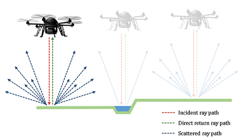
A representation of the use of a single-point rangefinder
According to Martin, at the time of the development of the UAV system in the aftermath of the 2011 disaster, the application of laser-based systems within low-altitudes was still very much in its infancy. ‘One of the challenges was to find a dependable range-finding system that was both lightweight and extremely rugged in order to survive being attached to the underside of the UAV. After much investigating, the AR2500 from Acuity was selected.’ The AR2500 is a compact, eye-safe, 905nm (NIR) laser rangefinder system with an accuracy of ±5cm over a range of 30 metres, making it ideal for mounting on an aerial platform and range-finding at low altitudes.
Up to 250,000 data points can be generated per second using the single-beam AR2500 system, according to Martin. While this resolution is enough to produce a detailed 3D radiation map, the Bristol group are looking to further increase it by mounting a 32 multi-laser lidar scanning system on the underside of a specially constructed UAV system. Each laser will operate at 905nm and together will be able to generate up to 700,000 data points per second. ‘As it’s a 32-laser system we can use the larger number of returns to track vegetation such as trees and grass, so we can actually do a lot more highly intensive data processing and analysis of the environment,’ said Martin. The group has plans to deploy the new system in June.
The Kromek GR1 gamma-ray spectrometer, which was used alongside the AR2500 to produce the radiation map in the initial set up, utilised a 1cm3 cadmium-zinc-telluride (CZT) crystal to achieve high spectral resolutions and radiation sensitivity. For Martin, however, the crystal itself presented a minor challenge in the development of the UAV system. ‘CZT is not readily grown in large crystal volumes,’ he said. ‘It is hoped that this high-sensitivity detection medium will be grown more effectively over the coming years, to enable larger and even more sensitive detectors to be produced – the increased growth of CZT crystals will be a major advancement in high spectral-resolution detection.’
Another challenge encountered by the researchers occurred when the UAV flew at specific heights over specific depths of water. In these positions, the lidar would return spurious data results, and to counteract this, the researchers had to make inclusions to the algorithm to both identify and then re-process any anomalous measurement values.
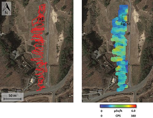
Flight path of the UAV taken during a site survey (left) and the corresponding radiation distribution map
According to Martin, while advances can be made to computationally eliminate these erroneous returns, the greatest photonics improvements that could benefit airborne radiation mapping will be the development of lightweight radiation detectors. He said the development of new types of radiation detector are already underway that make use of semi-conductor uranium dioxide – a material offering high gamma-ray stopping potential. Silicon and diamond-based systems are also being explored, all of which will be lightweight, Martin added.
Of all the challenges faced by the group in conducting their work with aerial lidar systems, the short UAV flight times achievable by current battery technology proved to be the greatest factor, limiting them to around 30 minutes of operation; in this time, the team were able to cover approximately one square kilometre. With further developments in battery technology, combined with new photonics technologies that draw less power, larger areas of land could be imaged by the group’s UAV-mounted systems.
Longer life, longer flight
With battery life being a significant limiting factor in UAV surveillance applications, it is essential that inspection systems collect as much data as possible with each pass over hazardous areas in order to maximise battery efficiency.
Headwall Photonics addresses this through offering a series of UAV-mountable hyperspectral imaging sensors equipped with diamond turned diffraction gratings that maximise the efficiency of UAV flights through delivering an aberration-corrected performance over a very wide field-of-view.
‘Aberration correction ensures square pixels not only directly beneath the line of flight – as you’d expect – but also off to the edges,’ explained Christopher Van Veen, marketing manager at Headwall Photonics. With a wider, clearer field-of-view Headwall’s hyperspectral sensors can capture more information with each pass over a section of land, and thus can capture more data in the time enabled by the UAV’s short battery life.
According to Van Veen, the aberration-corrected performance is made possible by the high-quality groove structures of Headwall’s diamond turned diffraction gratings, which reflect incoming light in such a way that a very high signal throughput – and therefore precise data, square pixels and a high signal to noise ratio (SNR) – is delivered to the focal plane array. Hyperspectral sensors featuring these gratings therefore provide a great degree of accuracy in distinguishing and classifying similar spectral signatures – an ability important for intelligence, surveillance and reconnaissance missions.
Headwall’s sensors are being used to define ground targets in military applications such as identifying improvised explosive devices (IEDs) by their chemical signatures. ‘Anything that can be tagged with a spectral signature and identified with respect to what it is and where it is,’ said Van Veen. ‘In every case, the mission objective is clear: “What am I looking at?” Often, the answer is never clear using normal visual techniques. And although camouflage can largely mask the presence of chemical compounds or materials, it cannot completely hide them from a hyperspectral sensor.
Through the fog
In any hazardous military environment, the ability to transmit information reliably and in high detail, regardless of the environmental conditions, is vital. For this purpose, Laser Components offers a range of avalanche photodiodes suited to detection in wavelengths ranging from UV right through to infrared. ‘Active areas from 500 to 3,000µm in silicon and 80 to 350µm in InGaAs offer a variety of options for focussing incoming light,’ said Dave Barry, technical sales engineer at Laser Components. ‘High responsivities, low dark current and noise make the detectors ideally suited for low-light environments and optical communications.’
According to Barry, for applications where visibility is restricted, 1,550nm lidar sources are also becoming increasingly prevalent for explorative applications: ‘With superior transmission through fog, smoke and vapours, 1,550nm sources are finding increasing application in low-visibility environments.’ This wavelength also adds the benefit of being undetectable by common night-vision goggles, so opponents can be identified without being spotted by enemy equipment.
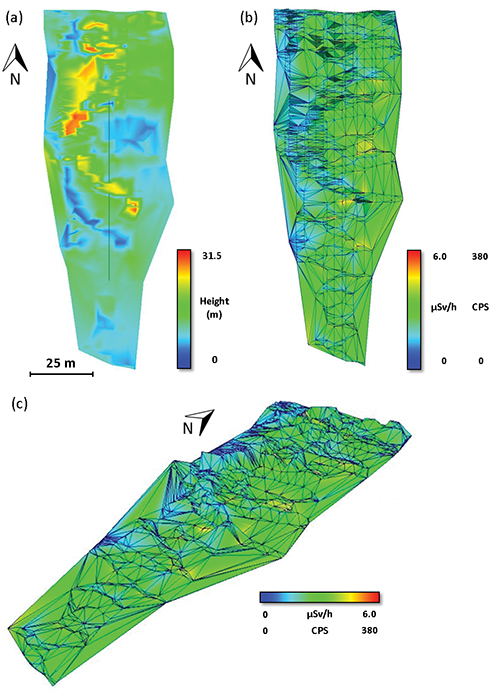
A 3D radiation map produced by an airborne lidar and radiation detection system
Barry believes that despite being on the rise in military application usage, 1,550nm diodes are not without fault: ‘Pulsed laser diodes at 1,550nm are typically less amenable to overdriving than their 905nm counterparts, which means that there are limitations in duty cycles. This is really a product of the material itself but since the market is moving towards detection at 1,550nm, there is always room for development in this area.’
Certain range-finding applications also require homogeneity on the device output in order to view targets in maximum detail. Laser Components’ compact, homogeneous-output 905nm SQF series of pulsed laser diodes with square fibres are designed for this purpose. With uniform near-field homogeneity and powers up to 25W, these devices are well suited to distinguishing and identifying enemy ballistics from long range in the field.
Military mapping
Exploring hazardous military environments using lidar has been one of the focuses of Dr Christina Grönwall at the Swedish Defence Research Agency (FOI) while working alongside the Swedish armed forces.
‘The armed forces are interested in generating up-to-date 3D images of the terrain or urban area around them in a short span of time for planning purposes,’ said Grönwall. ‘They also like the fact that lasers can penetrate vegetation and reveal what’s hidden underneath a tree canopy. In the projects that we have been working they are interested in identifying enemy troops and vehicles.’
In their research, Grönwall and her colleagues have been experimenting with a variety of laser scanners, sensor concepts, multi-rotor UAV platforms, and signal processing techniques. One such scanner used by the team has been the Riegl VZ400, a fully integrated, accurate and compact mobile laser mapping system.
While being capable of providing high-quality results in the field, the Riegl VZ400 came with certain drawbacks, according to Grönwall: ‘The Riegl is quite slow, but it has a very good resolution,’ commented Grönwall. ‘For us, it’s a sensor that, with some delays, can give really good data that can be used for signal processing.’ She added that although the sensor is ideal for research, the Riegl system would not be suitable for military usage because of such delays.
The FOI team are currently exploring the possibility of mounting a photon counting device onto a larger UAV platform in order to obtain higher-resolution 3D images. ‘This kind of system might be like the larger UAVs that are used by the armed forces as it is more robust to wind and other conditions,’ remarked Grönwall.
The new device will enable the group to distinguish centimetre-scale details at kilometre-scale distances, while also enabling them to penetrate vegetation from a longer range. However, because of this increase in resolution, the team will have to store and process larger amounts of data, which requires on-board storage or high-bandwidth communication to a ground station. Grönwall added that because photon counting systems are still maturing as a technology, more data processing must be performed post-collection to reduce noise
In addition, the team is looking to improve the UAV platform by implementing simultaneous localisation and mapping (SLAM) on the drone. ‘With this technique, you use the data to get a better understanding of your own position based on each data set that you collect,’ explained Grönwall. ‘If you know where you start, then you can use this technique even if you don’t have any GPS information, and you do all the positioning based on the data that the UAV collects with the laser scanner and the inertial navigation system.’ In military situations where there is little room for error and reliability, being able to locate the drone accurately without GPS assistance could be vital.
Criminals are becoming more sophisticated in eliminating explosive chemical residues from their clothing, belongings and vehicles, making it more difficult for security threats to be identified. To stay one step ahead, first responders, military and security personnel will require trace-level detection methods that are sensitive and easy to deploy at airports and borders.
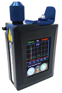
‘As users of the equipment have begun to take these tools into the field, it’s important to have a rugged, temperature-stable and compact system to fit into a field portable unit,’ commented Marco Snikkers of Ocean Optics’ business development and strategy.
Ocean Optics has addressed this need through the development of the IDRaman mini (pictured), a robust and compact handheld Raman spectroscope for the instant identification, authentication or screening of hazardous elements out in the field.
The spectrometer works from an on-board spectral explosives library of over 60 known compounds and precursors to enable the fast identification of unknown substances. The device operates using raster orbital scanning to probe samples in a daisy-like pattern, providing high sensitivity and consistent chemical identification.
To complement the handheld spectrometer, Ocean Optics has also developed reusable gold/silver alloy substrates that enhance the Raman signal by factors up to 1011, enabling the detection of explosives from only trace levels (parts per billion) of residue.
The SERS substrates have already been proven to be able to detect minute levels of RDX (a common explosive often mixed with plasticisers to make C-4), TNT, PETN and chemical warfare agents.